


25 January 2018
OS says it has both the digital and geospatial expertise required to understand the challenges and capabilities of connected vehicles.
Supported by the Industrial Challenge Strategy fund, the four-year E-CAVE project will focus on the challenges of creating effective connected environments using OS’ digital data expertise.
At the heart of the project is a focus on positioning and safety, underpinned by geospatial technologies and standards. OS claims it has both the digital and geospatial expertise required to understand the challenges and capabilities of CAVs, and that precise location is not only a fundamental part of its work but also vital for the efficient collaboration between vehicles, which includes the exchange of map messages.
OS says E-CAVE will enable real-time vehicle-to-vehicle (V2V) and vehicle-to-infrastructure (V2I) data sharing, using open standards and architecture that will “transcend” proprietary interests.
The organisation will also be engaged in supporting and collaborating with test projects that are being overseen by Meridian, a government-backed industry consortium for the development of CAV technology in the UK.
OS reckons it is a neutral partner and has a “good understanding” of the national infrastructure working alongside existing government departments local authorities and the Highways Agency.
The organisation says it works on a daily basis with the sensor and visual image technology that is being adopted by CAVs to help them navigate.
“We will be using a CAV development platform vehicle to investigate how CAVs understand and communicate their position relative to other vehicles and the real world environment,” says an OS spokesperson.
He adds that the project is focused on discovering the requirements and standards to augment the safe operation of autonomous vehicles by the exchange of messages between vehicles and traffic management systems.
“From the simple pedestrian crossing up to complex multi-lane intersections, autonomous vehicles will perform better and more efficiently where they can communicate with traffic management systems that can see the bigger picture of the traffic flow and intentions.”
OS adds that the aim is that all the connected drivers of the future can benefit from fewer accidents, while towns and cities benefit from less pollution from more efficient traffic flow.
The organisation already has experience of being at the heart of national infrastructure projects, such as this planning trial in Bournemouth which looked at the effects of the built environment on proposed 5G frequencies.
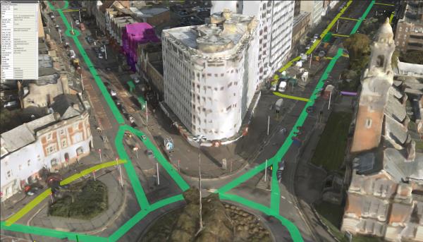
E-CAVE is a development of OS’ involvement in the CityVerve smart city project in Manchester which looked at the infrastructure capability for map messages. 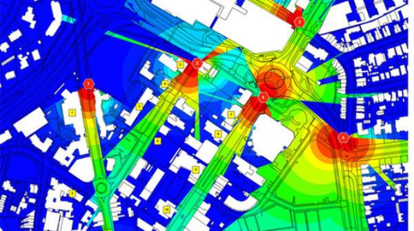
Here, its work included the Atlas initiative which studied and identified data critical to the efficient operation of autonomous vehicles, and the development of a digital twin planning tool for the roll out of 5G.
OS CEO Nigel Clifford says E-CAVE will provide the government with evidence-based insights to speed up the deployment of connected environments.
He says: “The learning we gain will show the UK to be an exemplar, and the infrastructure design which comes from this activity can be scaled up and used internationally.
“Our primary aim though is to ensure driverless vehicles will be connected and collaborating to ensure the safety of the public at all times.”
Meanwhile, business secretary Greg Clark believes low carbon and self-driving vehicles are the future, and says the government is paving the way to ensure the UK is best placed to seize the opportunities presented by their development.
He says: “With its centuries of experience in mapping and its status as a big data powerhouse, Ordnance Survey’s new project will make a valuable contribution to us achieving our bold ambitions accelerating the development and deployment of driverless technology in the UK.”