


26 May 2017
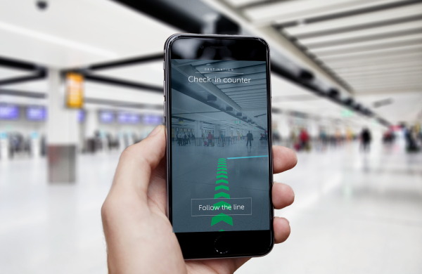
The AR wayfinding tool enables passengers to see directions using their mobiles.
Around 2,000 beacons have been installed across Gatwick Airport’s two terminals providing an indoor navigation system that is said to be much more reliable than GPS.
The new system, which is part of Gatwick’s £2.5 billion transformation programme, enables augmented reality wayfinding for passengers – claimed to be a world first for an airport.
The lack of satellite signals makes road-based navigation systems, such as Google or Apple maps, unreliable indoors.
As a result, Gatwick has deployed a beacon-based positioning system to enable reliable ‘blue dots’ on indoor maps. This could eventually be used within a range of mobile airport, airline or third party apps.
The beacon system also enables an augmented reality wayfinding tool. This allows passengers to see directions in the camera view of their mobiles so that they can be easily guided to check in areas, departure gates, baggage carousels, etc.
It’s claimed battery powered beacons kept logistical complexity and costs low, with deployment taking just three weeks followed by two months of testing and calibration.
The new navigation technology is currently being integrated into some Gatwick apps, and the airport is in discussion with airlines to enable the indoor positioning and wayfinding tools to also feature on their app services.
No personal data will be collected by Gatwick, although generic information on ‘people densities’ in different beacon zones may be used to help improve airport operations including queue measurement, streamlining passenger flows, and reducing congestion.
It’s claimed airlines could go further and, with the consent of their passengers, send reminders on their airline app to latecomers, for example, or find out where they are and make an informed decision on whether to wait or offload their baggage so the aircraft can take-off on time.
Retailers and other third parties could also use the beacon system to detect proximity and send relevant offers or promotional messages, if the passenger has chosen to receive them.
The end to end ‘indoor blue dot’ service is managed by PointrLabs. Its CMO Axel Katalan says: “Our SDK enables battery-optimised, multi-platform and high performance positioning and other features such as 3D wayfinding through AR and on-screen translation, all of which are now available to be used by Gatwick and their partners as simple as drag and drop.”
The tech stack comes with an indoor map. This shows up to date content, positioning within three metre accuracy, and navigation technology that is said to be dynamic and recognises.
For example, it identifies areas currently under construction, or multi floor navigation including when taking lifts, proximity to retailers, etc.
App developers need to simply use the beacon registry or PointrLabs SDK in their app to enable features.